All-volunteer Friends of Five Creeks has Worked for clean water and healthy watersheds since 1996
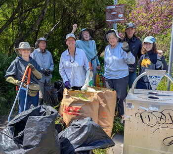
Hands on, we revive natural areas that a welcome people and animals from Bay to hills, Berkeley to Richmmond. We collect citizen-science and other information important to making decisions, especially in light of climate change. We also collaborate and advocate with local agencies and other nonprofits.
Join us to make a difference!
TENDING NATURE, HANDS ON
Join our small, informal Tuesday morning Weed Warriors! No obligation, no RSVP – come when you can. Email us for more info, or sign up to be notified of locations.
Monthly (more or less) work parties are open to the public — scroll down for details.
Email us about events for your group on your schedule, or adopting a site.
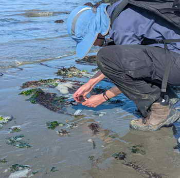
Citizen Science, monitoring
Use iNaturalist and other tools to contribute to informed policy, build baselines for climate change, and get to know plants and animals.
Current focus is at Aquatic Park and Albany’s varied shoreline. We also have opportunities for birders and those who know native plants, as well as more quantitative monitoring. Email us about your interests.
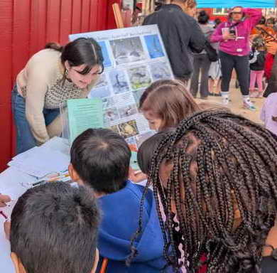
partnering, teaching, advocating
Our small group has worked with many others over the years. Many skills welcome!
Currently, we are looking for help developing with a future exhibit at the Berkeley Historical Society and Museum and partnering with Shark Stewards and others to help with environmental challenges at Aquatic Park’s lagoons.
upComing ways to help nature
No December public work party! Our Tuesday morning Weed Warriors will meet, though heavy rain cancels! Sign up on our E-news or About page to get weekly notices of where we’ll be. No obligation, no RSVP — just come when you can.
Enjoy and explore nature: Help with holiday high- and low-tide citizen science: During the year’s highest daytime tides, contribute to the California King Tides Project by photographing and reporting. You will be creating a record of change and a foretaste of sea-level rise to come. Highest levels will be comfortable mid to late mornings, Thurs. & Fri., Dec. 4-5, and Fri. & Sat., Jan. 2 & 3. See a good tide chart for your location. F5C volunteers and interns have recorded local sites for years, rain or shine, with storms ideal. Email if interested in helping. We may schedule an easy walk Jan. 3.
Observe creatures between and below tidelines at minus tides: Lowest tides are mostly after dark through January, but they will drop low close to dusk Dec. 31 and Jan. 1 & 2, as well as Jan. 30 & 31. Looking west at sunset isn’t ideal, but if weather is not stormy, we welcome a few helpers interested in the wonders and willing to download and learn the basics of iNaturalist in advance. Email if interested.
We also seek GPS’d photos of flooding, damage, and erosion during and after storms, on shorelnes, tidal channels and creeks, and anywhere else, including hillside slippage and recurrent street flooding. Get in touch!
What’s New
The East Bay Regional Park District’s plans for the North Basin Strip – Schoolhouse Creek area are now online here. The link has extensive background and info on other ways to comment. The Park District’s Executive Committee could vote as early as Wed., Dec. 9, and the full board Dec. 16. Agendas and info on how to comment at board meetings will be here.
This plan has many strong points. More details are on our page on Schoolhouse Creek. We at Friends of Five Creeks are disappointed that the Park District has chosen not to “daylight” the mouth of Schoolhouse Creek.
Most important, this plan must deal with how to adapt to rising sea levels and increasingly intense storms. We sent the District Board and planners a strong memo detailing how background documents and consultants’ reports misconstrue, misrepresent, and selectively ignore evidence, building a case for gravel and cobble as a way to lessen erosion. These techniques are being piloted at projects around the Bay, making them attractive to consultants and agencies. However, they remain experimental. Selling them on false evidence risks millions in costs and maintenance, as well as real danger.
Friends of Five Creeks’ two recent slide shows, below, give a picture of conditions and ongoing change along shorelines in the North Basin Strip and throughout our area.
Slide shows on current shoreline issues
Our slide show, “Virginia Extension: Conditions and Implications” Click here to view slide show in a new window. These slides show the decrepit conditions that led us to conclude that in the face of rising sea levels, this flood-prone, eroding old dump road should be allowed to become salt marsh, with a new road much farther inland. (The North Basin plan has accepted this approach.) This is a large file! Please be patient. It is meant to be viewed on a large screen. Slides are set to advance slowly, for reading and a close look.
How are our East Bay shorelines changing? Tracking history as climate changes. Click here to view slide show in a new window. This is a large file! Please be patient. It is meant to be viewed on a large screen. Slides are set to advance slowly, for reading and a close look. This is a beginning effort — please help us build these records!